

Some Prehistory that Helps Explains How BFL Came to Exist
Before BFL was BFL, it was once something quite different with a very different purpose.
Enter George Brackenridge (1832 - 1920), a banker who would become the longest serving Regent for UT Austin. Some southerners like George Littlefield, another Regent, considered Brackenridge a “carpet bagger,” a derogatory term for a northerner who went to the south to benefit financially from the Reconstruction following the Civil War.
 |
| Power House and dam, 1892 |
Whatever one considered Brackenridge, he became involved with some business people that wanted to industrialize the city of Austin. This was in 1880 and at the time, the population was only 12,000 people. They goal was to create a hydroelectric dam that would power factories along the shore of the Colorado River. Brackenridge bought about 500 acres that he planned to serve as the site for the dam. Additionally, Brackenridge helped fund the building of the dam, and supplied some of the building material through a quarry he established on the property. (The current fences on BFL start and end where the quarry once began and ended.) To build this dam, the city of Austin would go into debt, hoping it would lure cotton mills to the banks of the river.
The dam was finished in 1893. It was sixty feet high and stretched almost 1200 feet across the river. At the time, it was one of the largest dams in the world. It backed up into a lake that was called Lake McDonald, named after mayor John McDonald who had drummed up support for the dam. This lake would back up about 35 miles.
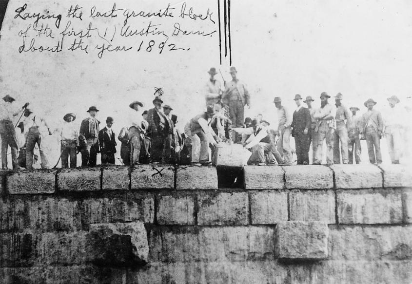 |
| Inserting the last granite block, 1892. (LCRS Archives W100198) |
However, the dam was not without its problems during construction. Thomas Taylor, engineer and first dean of the College of Engineering at UT, was critical of the dam project. He felt they were overestimating the electrical potential of the Colorado River, and underestimating the flash flood potential. He was critical of the placement of the dam as it was right over the Balcones Fault line. After the dam’s completion, Taylor began measuring the buildup of silt behind the dam. By early 1900, half of the depth behind the dam was silt. This was because there were many people moving to the area to start farms. They were clearing the land and the topsoil was washing off into the tributaries.
The dam was constructed of limestone blocks from Brackenridge’s tract. They had a granite veneer and seemed strong. However, the dam wasn’t reinforced. In fact, many engineers had quit over the course of the project, frustrated with Mayor McDonald meddling with the design, and the use of poor construction materials.
Inevitably, enormous rainfall would cause the dam to break on April 7, 1900. This outpouring of water was at first a spectacle that attracted Austinites, until the dam broke and then things got serious. Water would blast into the powerhouse and kill eight people. Lake McDonald also vanished. Austin would be without power for several months.
 |
About 100 meter stretch of this dam became loose and washed downstream, heavy debris creating Red Bud Isle.
Depth of water at the break would have been about 80 feet high and 330 yards wide, forming a tsunami. This tsunami would gain greater height just downstream as it neared today’s BFL and reached a constriction in the river basin bounded by the 200 foot bluff to the west. Much of the sediment that had built up behind the dam for seven years was directed opposite the bluff and over the old growth ripiarian forest of what today is BFL, depositing a deep layer of sediment and killing most of the trees.
Only older and taller pecan trees would survive. A few of these giant pecans are still alive today! The creek bottom that drains from the area of today’s MUNY across to the river is home to some of the giant trees a buried ~ 45-50’ in silt. Over the last 120 years, periodic flooding rains, including those of Hurricane Harvey, have eroded a steep gulley through this silt deposit, exposing the original root zone of one of the original pecan trees.
After the loss of the dam, George Brackenridge had no further business interest in the project, and was a Regent at UT at this point, so he just donated the 500 acres to UT Austin in 1910. It would become student housing and in 1966, it officially became the Brackenridge Field Lab we know today. William Frank Blair was its first director and PI of the NSF grant that funded its infrastructure.
In retrospect, it seems clear that the site that became BFL in the 1960s, was available only because its long axis is defined by Brackenridge’s abandoned quarry, and its lower zone by deep loose sediment. They are ironically linked to the failed dam that the quarry helped construct. These traumatic and human-caused disturbances to the landscape have exact known times that they occurred and, not being as developable at the time, were left to natural recovery. Understanding ecological restoration on planet earth is one of the most pressing issues for future generations. BFL provides UT students unique opportunities to investigate “hands-on” how biodiversity responds to such abiotic disturbances a well as the impact of biotic disturbance of invasive species like fire ants.
written by Nicole Elmer, January 20, 2020, via a talk given by Dr. Larry Gilbert at BFL, September 2019. The original article appears here.

